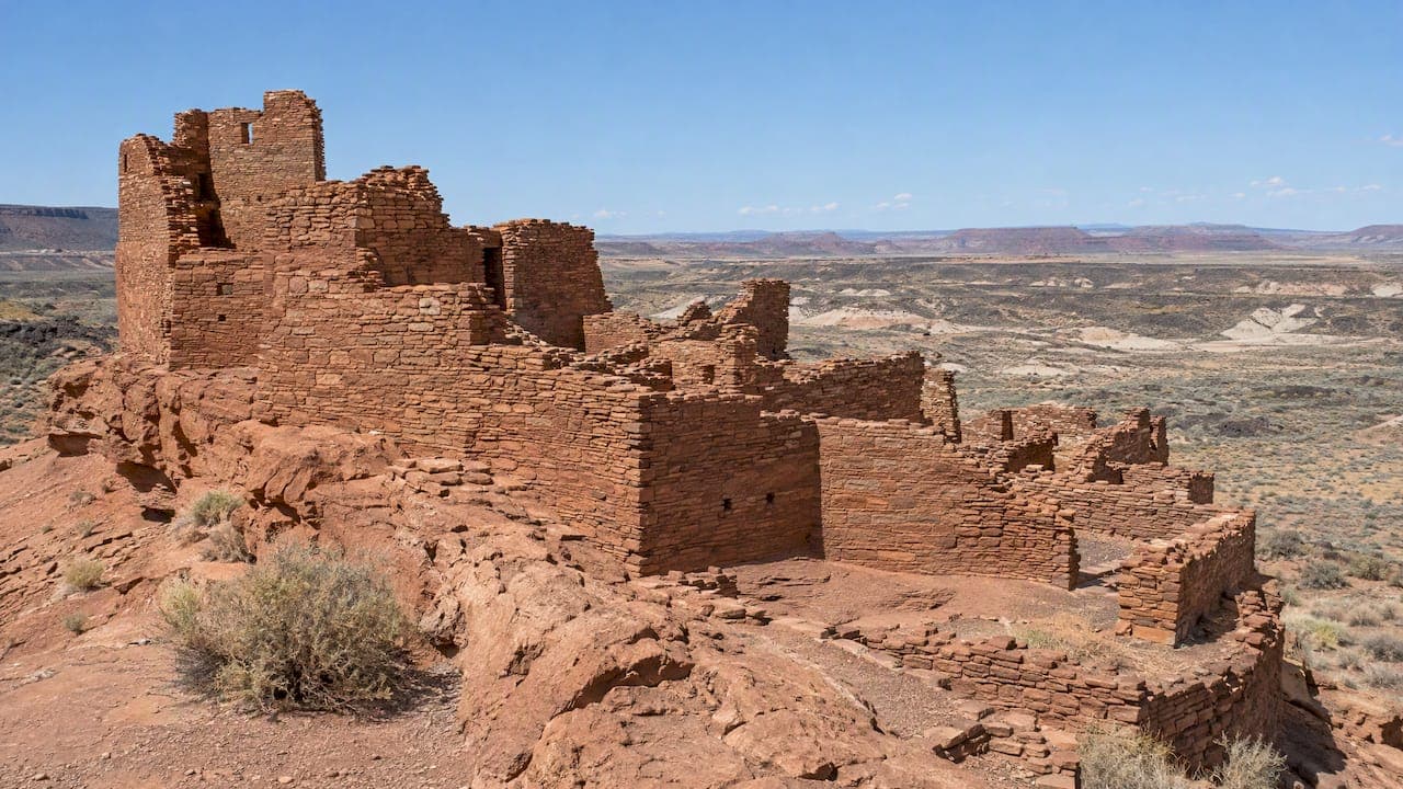
Wupatki Pueblo was built in the early 1100s, in the years after a volcanic eruption blanketed the surrounding land in ash, and it became one of the busiest trading centers in Northern Arizona. According to the National Park Service, from the early 1100s to the mid-1200s this 104-room Ancestral Puebloan structure was a hub for trade and agriculture, with a ceremonial ballcourt and a large community room. It sits about 30 miles north of Flagstaff, and its story is easier to grasp once you know the volcano, the farmers and the trade routes that shaped it.
This guide covers who lived here, why they came, what the buildings tell us, why the site is not truly "abandoned," and how to visit without wasting the experience.
TL;DR
- Wupatki (say "woo-POT-kee") is the largest free-standing pueblo in Northern Arizona, with 104 rooms, a ballcourt and a community room.
- The nearby Sunset Crater eruption around 1064 CE pushed people out at first, then left ash that helped farming and drew new settlers in the 1100s.
- At its peak, roughly 2,000 people lived within 50 miles, and Wupatki was the regional gathering place.
- Thirteen associated tribes, including the Hopi and Zuni, regard the site as ancestral, not abandoned.
- Entry is $25 per vehicle for seven days, and the main trail takes about 30 minutes, so pair it with Sunset Crater.
Table of Contents
- What Wupatki Pueblo Is
- The Eruption That Reshaped the Basin
- Who lived at Wupatki?
- Reading the Buildings
- Why Wupatki Was Left, and Why "Abandoned" Is the Wrong Word
- A Rougher Chapter: The 1930s
- Perspective: Why We Send Guests Here Before the Canyon Crowds
- Planning Your Visit
- Seeing Wupatki With a Private Guide
- FAQ
- Sources
What Wupatki Pueblo Is
The National Park Service calls it the largest free-standing pueblo structure in Northern Arizona, and describes it as the largest trading center within 50 miles roughly 900 years ago. The walls are built of local sandstone and rise from a rocky outcrop above the Painted Desert, in a landscape that looks, at first glance, far too dry for a thriving community.
It is also only one site among many. Wupatki National Monument protects more than 2,600 ancestral Puebloan sites, most of them small field houses, farmsteads and storage structures scattered across the basin. The pueblo is the one you can walk through easily, which is why it gets the attention.
The monument itself was established by President Calvin Coolidge on December 9, 1924, to preserve Citadel and Wupatki pueblos. Its boundaries have been adjusted several times since.
The Eruption That Reshaped the Basin
You cannot tell the Wupatki story without Sunset Crater. The volcano erupted around 1064 CE, and the NPS describes the displacement of earlier residents followed by a surge of new villages within a generation. Other accounts of the period, such as the World History Encyclopedia entry on Wupatki, date the eruption to roughly 1064 to 1065 CE and describe ash and cinders spreading across a very wide area.
The key detail is the soil. A layer of cinders can hold moisture and reduce evaporation, so what looked like catastrophe became opportunity. Add the cooler, wetter weather that the NPS notes for the early 1100s, and farming in a high desert basin suddenly worked. Families moved in from several directions, and the Wupatki Basin filled up.
If you want to see the other half of that story, the crater itself is a short drive away. Our guide to choosing the right Sunset Crater hike explains the trails, and our page on Sunset Crater Volcano National Monument covers the site.
Who Lived at Wupatki
People have lived in this area for over 13,000 years, but the pueblo belongs to a specific moment. By the early 1100s, the NPS counts around 2,000 people within 50 miles of Wupatki Pueblo, communicating, cooperating and trading with one another.
The residents were not a single tribe in the modern sense. Archaeologists use the term Sinagua for people who inhabited central and northern Arizona from about A.D. 600, and Wupatki drew neighbors with different traditions. Today the NPS says thirteen traditionally associated tribes, including the Hopi and Zuni, connect to the site. Population at the pueblo itself was modest: the NPS data in our research puts it at about 85 to 100 people by 1182 CE, far fewer than the number who gathered here for events.

Trade, farming and the regional network
The basin was a crossroads. Farmers grew corn, beans and squash with whatever rain fell, and the surplus, along with pottery, shell and other goods, moved through the pueblo. That is why the NPS uses the phrase "trading center" and why the architecture looks the way it does: Wupatki was built to host people, not just house them.
Reading the Buildings
The trail loops around the main pueblo. Knowing what to look for turns a 30-minute walk into something much richer.
| Feature | What it tells you |
|---|---|
| 104 rooms | Multi-story living and storage space built in stages over the 1100s |
| Community room | A large gathering space, likely used for dances and ceremonies |
| Ballcourt | An open oval used for games and public events, a sign of cultural exchange |
| Blowhole | A natural vent linked to underground fissures that moves air in and out |
The community room is the best example. Its bench seating and central hearth suggest large gatherings, religious ceremonies and trade. The ballcourt supports the same reading, and sources such as the NPS pueblo page place it behind the visitor center, within the same short walk.
The blowhole and Yaponcha
Near the far end of the trail you will find a natural blowhole. It connects to underground fissures and breathes air in and out as pressure changes. The NPS notes that Ancestral Puebloan people associated it with the wind god Yaponcha. Stand beside it on a calm day and you can feel the airflow, which is exactly the kind of detail that makes the site feel alive.

Why Wupatki Was Left, and Why "Abandoned" Is the Wrong Word
By the mid-1200s, the community that had formed here had largely moved on. The NPS describes occupation from the early 1100s to the mid-1200s. The precise causes are debated, and anyone who gives you a single neat answer is oversimplifying. Shifting rainfall, changing farming conditions and wider migration across the Southwest all play a part in the accounts you will read.
What is not debated is how descendants see it. The NPS states that the site is not considered abandoned by the thirteen associated tribes. They hold that the people who lived here remain as spiritual guardians, and clan members still visit and care for the site to deepen their understanding of their history. That is worth carrying with you on the trail: you are walking through a place that is part of living cultures. Our pages on Arizona Native American culture and Native American arts and culture in Arizona give more background.
A Rougher Chapter: The 1930s
The site was not always treated gently. The NPS notes that in the 1930s, illegal whiskey distillers near the pueblo scavenged ancient timbers to fuel their vats. Early archaeology was also rough by modern standards. The calm, protected walk you take today is the result of decades of stewardship.
Perspective: Why We Send Guests Here Before the Canyon Crowds
Most people who book with us are heading to the Grand Canyon, and they should. But the guests who talk about their trip afterward often bring up Wupatki. The reason is simple: it answers a question the canyon raises, which is who lived in this country and how they made it work.
We suggest treating it as a story with three chapters rather than three separate stops. The volcano explains the soil, the pueblo shows what people built once the soil improved, and Walnut Canyon shows a different style of life in the cliffs. The National Park Service itself manages the three Flagstaff-area monuments as one unit because their histories are linked, according to the Sunset Crater foundation document. Seeing only one of them leaves the narrative half told.
The other thing we tell guests is to slow down. The loop trail is short, and the temptation is to photograph the walls and leave. Sit near the community room for a few minutes and think about the dances and gatherings it held. That is the visit.
— Chris
Planning Your Visit
Fees and passes
According to the NPS fee page, entry is $25 per vehicle and is valid for seven days. The Flagstaff Area National Monuments pass costs $45 and covers Wupatki, Sunset Crater Volcano and Walnut Canyon for one year from purchase. The visitor center is cashless for pass sales. Fees can change, so check that page before you go.
Hours and timing
The NPS fee page lists the visitor center as closed Tuesday through Thursday from November 2 through March 7, so winter visitors should confirm current days before driving out. Budget about 30 minutes for the main pueblo trail, plus time in the museum and at the blowhole. The monument's Places To Go page also lists current park alerts, which is worth a look because road closures at neighboring Sunset Crater have occurred.
Getting there without getting stuck
The most direct route is the 35-mile scenic loop road from US-89 that links Sunset Crater and Wupatki, described on the NPS directions page. Do not rely only on phone navigation. The NPS warns that GPS can send drivers onto rough, unmaintained forest roads that need high-clearance four-wheel drive. Follow posted signs and the main highway.
Sample half-day order
- Start at Sunset Crater to see the volcano that changed everything.
- Drive the loop road toward Wupatki, watching the landscape open into the Painted Desert.
- Visit the museum, then walk the pueblo trail, ballcourt and blowhole.
- If time allows, add Walnut Canyon for the cliff dwellings, covered on our Walnut Canyon National Monument page.
For a quick reference on the monument as a whole, see our Wupatki National Monument page.
Seeing Wupatki With a Private Guide
Driving yourself works if you like to explore at your own pace. If you would rather have the history explained as you walk, and skip the logistics, our private Four National Monuments tour includes Montezuma Castle, Tuzigoot, Wupatki and Sunset Crater. It starts from $309 per person, it is fully private with no shared buses, and it includes door-to-door pickup and all fees.
If you are staying in Flagstaff, see our Grand Canyon tours from Flagstaff page for how pickup works, or read our Flagstaff guide. If the canyon is the main goal, our private Grand Canyon day tour starts from $319 per person, and the Grand Canyon and Ancient Ruins tour starts from $339 per person.
FAQ
How do you pronounce Wupatki?
It is pronounced "woo-POT-kee," with the stress on the middle syllable. The NPS uses that pronunciation on its visit page.
Is Wupatki National Monument worth visiting?
Yes, especially if you care about the history behind the landscape. The main trail is short, about 30 minutes, but the pueblo, ballcourt, community room and blowhole make it rich. It pairs well with Sunset Crater on the same loop road.
Who lived at Wupatki?
Ancestral Puebloan and Sinagua peoples lived here, with neighbors from several traditions gathering and trading. Thirteen associated tribes, including the Hopi and Zuni, regard the site as ancestral today. By 1182 CE, about 85 to 100 people lived in the pueblo itself.
Are there Native American ruins near Flagstaff?
Yes. Wupatki, Sunset Crater and Walnut Canyon are the Flagstaff Area National Monuments, and a single $45 pass covers all three for a year. Wupatki has the large pueblo, while Walnut Canyon has cliff dwellings.
Sources
- Visit Wupatki Pueblo, National Park Service
- Wupatki National Monument, National Park Service
- Wupatki Pueblo and Blowhole, National Park Service
- Arizona: Wupatki National Monument, National Park Service
- History and Culture, Wupatki National Monument
- People, Wupatki National Monument
- Sinagua, National Park Service
- Fees and Passes, Wupatki National Monument
- Places To Go, Wupatki National Monument
- Directions and Transportation, Wupatki National Monument
- Sunset Crater Foundation Document, National Park Service
- Wupatki, World History Encyclopedia