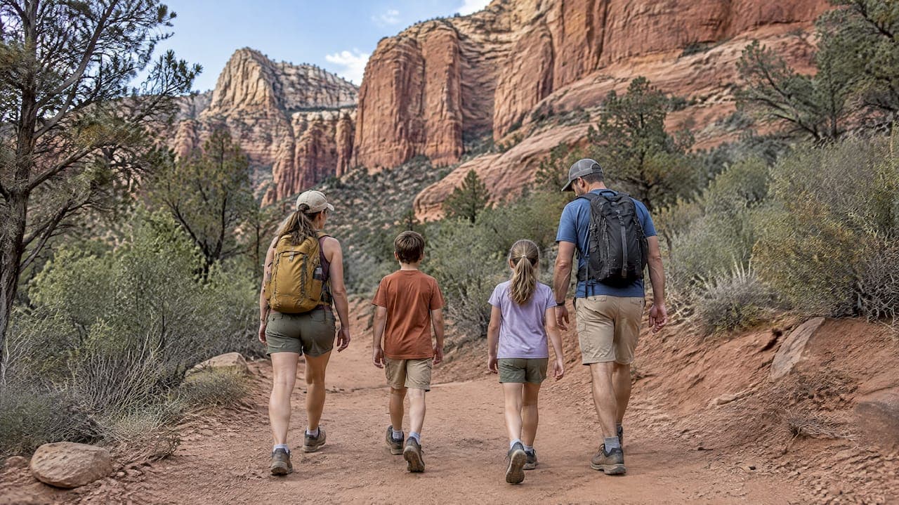
Bell Rock Pathway, the first 3 miles of West Fork Trail, Fay Canyon, Red Rock State Park's loop trails, Red Rock Crossing, the short approach to Devil's Bridge, and the Airport Mesa viewpoint are the best easy hikes in Sedona for families. An "easy" trail here means a flat or gently rolling surface, minimal elevation gain, a clear turnaround point, and a trailhead you can actually park at. Before you go, check shuttle and parking rules for your chosen trail since several popular routes limit car access on weekends.
TL;DR:
- For strollers or visitors with limited mobility, choose Bell Rock’s smoothed section or Red Rock Crossing’s paved walkway; both avoid rough footing.
- The free Sedona Shuttle serves several trailheads Thursday through Sunday throughout the year; lots can fill before 9 a.m., so use designated shuttle parking.
- The Devil’s Bridge viewing approach covers 1.8 miles round trip without the arch climb; Cathedral Rock requires steep scrambling and is not for beginners.
- For summer hikes over a mile, carry at least one liter of water per person; during active monsoon storms, avoid narrow washes.
Table of Contents
- Easy Sedona Hikes at a Glance
- Per-Trail Facts for Planning Your Hike
- Best Trails and Segments for Kids and Mobility-Limited Visitors
- Getting to Trailheads: Shuttle, Parking, and Passes
- Weather, Footwear, and Staying Safe on Easy Trails
- How to Pick the Right Easy Hike for Your Group
- Local Insight on Sedona's Easy Trails
- Pairing an Easy Hike With the Rest of Your Sedona Day
- Why This Guide Prioritizes Short and Smooth Over Iconic and Strenuous
- A No-Fuss Way to Hike Sedona Without the Planning
- FAQ
- Sources
Easy Sedona Hikes at a Glance
If you only have time to scan one section, this is it. Each entry below is short, forgiving on the legs, and reachable without technical gear.
- Bell Rock Pathway (up to 3.5 miles one way): wide, hard-packed surface with constant red rock views, good for strollers on the first stretch, and listed as easy by the Forest Service.
- West Fork Trail, first 3 miles (about 6 miles round trip to that point): shaded canyon walk with multiple creek crossings, best for families comfortable with a little rock-hopping.
- Fay Canyon (2.2 miles round trip): flat, shaded, dead-ends at a natural arch viewpoint, a favorite for kids who want a destination.
- Red Rock State Park loops (various, from a half mile): paved and dirt paths through riparian terrain, with restrooms, picnic areas, and a visitor center.
- Red Rock Crossing / Crescent Moon (short walkways): creek access with paved sections, ideal for toddlers who want to wade without a real hike.
- Devil's Bridge, short approach (about 1.8 miles round trip to the viewing area): skip the climb onto the arch itself and still get a great photo from below.
- Airport Mesa viewpoint (under a half mile): minimal walking for one of the best sunset views in town.
- Little Horse Trail, first stretch (about 1 mile out): mellow start before the trail climbs toward Chicken Point.
- Marg's Draw (up to 3.8 miles, shorter options available): low-traffic, gently rolling, good for an early morning walk away from crowds.
- Soldier Pass, lower section (about 1 mile to the Seven Sacred Pools): mostly flat with one short rocky stretch.
Bell Rock, Red Rock Crossing, and the lower Soldier Pass segment are the three most stroller-friendly picks. Red Rock State Park charges a per-vehicle entrance fee, and several trailheads near Uptown require a Red Rock Pass or are served by the free shuttle instead of parking.
Per-Trail Facts for Planning Your Hike
Each of these profiles gives you the numbers you need before you lace up: distance, time, surface, and what makes it work for a beginner or a family group.
- Bell Rock Pathway. Distance: up to 3.5 miles one way, though most families walk a shorter out-and-back. Elevation change: about 185 feet over the full route. Surface: wide, hard dirt and rock, rated easy by the Coconino National Forest, which also notes mountain bikers and horses share parts of the path. Restrooms are available at the trailhead. This is the trail we point beginners toward first: pick a landmark, like the base of Bell Rock itself, and turn around there.
- West Fork Trail (first 3 miles). Distance: roughly 6 miles round trip to the 3-mile turnaround point, though the full trail continues much farther. Time: 2 to 3 hours for the easy section, according to the Forest Service. Elevation: gentle, starting around 5,325 feet. Surface: shaded forest path with several creek crossings on rocks or logs. There is no restroom at the trailhead, so plan ahead. A smart tip here is to choose an obvious landmark, a bridge or a specific creek crossing, as your group's turnaround point and set a time to be back there.
- Fay Canyon. Distance: 2.2 miles round trip. Time: about an hour. Elevation: minimal, flat canyon floor. Surface: packed dirt, mostly shaded by canyon walls. No restroom on site. The payoff is a natural stone arch visible from a short side spur, which makes a good motivator for younger hikers.
- Red Rock State Park loops. Distance: as short as a half mile for the main interpretive loop, with several connecting trails for longer options. Elevation: about 100 feet of gain on the shortest loop. Surface: mix of paved and packed dirt. Restrooms, a visitor center, and picnic areas are on-site, and there is a per-vehicle entrance fee. This is the single best option for families with very young children or anyone who wants amenities nearby.
- Red Rock Crossing and Crescent Moon. Distance: short walkways of a quarter mile or less to the water's edge. Elevation: flat. Surface: paved sections lead to a sandy creek bank, good for wading in warmer months. Restrooms and picnic tables are available. This spot works well paired with a scenic drive rather than as a standalone hike.
- Devil's Bridge, short approach. Distance: about 1.8 miles round trip if you stop at the viewing area below the arch rather than climbing onto it. Elevation: moderate climb near the end, which is where many families choose to stop. Surface: dirt road access then a rockier final stretch. No facilities at the trailhead, and parking is limited, so this works better by shuttle or an early arrival.
- Airport Mesa viewpoint. Distance: under a half mile round trip from the closest parking area. Elevation: a short, steady incline. Surface: packed dirt and some rock steps. No restroom at the overlook itself. This is less a hike than a short walk to one of the most photographed sunset spots in Sedona.
- Little Horse Trail (first stretch). Distance: about 1 mile out before the trail steepens toward Chicken Point. Elevation: gentle at the start. Surface: packed dirt with some exposed rock. No facilities. Good for a quick, low-commitment outing when you want red rock scenery without a full day of hiking.
- Marg's Draw. Distance: up to 3.8 miles for the full loop, with shorter turnaround options throughout. Elevation: gentle rolling terrain. Surface: dirt, often less crowded than trails closer to Uptown. No facilities on the trail itself. A solid pick for an early, quiet walk before the heat sets in.
- Soldier Pass (lower section). Distance: about 1 mile round trip to the Seven Sacred Pools. Elevation: mostly flat with one brief rocky climb. Surface: packed dirt, narrowing near the pools. No restroom at the trailhead, and parking is limited on a residential street, making this a good candidate for the shuttle.
One trail deserves a clear caution: Cathedral Rock is often listed alongside these easier hikes, but it is not an easy trail. The main route involves steep slickrock scrambling and hand-over-hand sections near the top, and it should not be treated as a beginner or stroller-friendly option despite its short overall distance.
Difficulty in Sedona rarely tracks with mileage alone. The Boynton Canyon Trail system, for example, is rated moderately challenging at 6 miles round trip with 931 feet of elevation gain, while some connecting routes in the same area stretch past 16 miles. Always check the surface and elevation profile for your specific trail, not just its length.
Best Trails and Segments for Kids and Mobility-Limited Visitors
A handful of short, smooth segments make Sedona workable even for strollers, wheelchairs, or visitors who tire quickly on uneven ground.
- Bell Rock Pathway's smoothed section along the SR-179 side has been widened for strollers and wheelchairs, according to Visit Sedona's accessibility guidance.
- Red Rock Crossing's paved walkway gets you to creek access without rough footing, and it has restrooms and shade nearby.
- The lower Soldier Pass segment, roughly a mile to the Seven Sacred Pools, stays mostly flat and is manageable for older kids on foot, though it is not stroller-friendly due to a narrow final stretch.
- Red Rock State Park's main loop offers the most reliable combination of pavement, shade, restrooms, and a visitor center close to the parking lot.
Morning hours, generally before 10 a.m., bring cooler temperatures and softer light for photos, which matters more in summer than any other planning detail. For toddlers who want water play without any real walking, Crescent Moon's sandy creek bank is the simplest option.
Pro Tip: Bring a compact folding stroller with slightly higher clearance rather than a full jogging stroller. It handles hard-packed dirt better while still folding down for the car.

Getting to Trailheads: Shuttle, Parking, and Passes
Sedona's most popular trailheads get crowded fast, and knowing the shuttle and pass system saves real time on a short visit.
- The Sedona Shuttle runs free trailhead routes Thursday through Sunday year-round, serving Cathedral Rock, Dry Creek Vista, Little Horse, Mescal, and Soldier Pass trailheads.
- Shuttle buses are wheelchair accessible and can carry up to three bikes, and no reservation is required to ride.
- On shuttle days, plan to park at a designated park-and-ride lot rather than circling for trailhead parking, since several lots fill before 9 a.m.
- Red Rock State Park charges its own per-vehicle entrance fee separate from any shuttle or Red Rock Pass system, and other trailheads in the national forest may require a Red Rock Pass.
The Sedona Shuttle operates year-round on a fixed Thursday-through-Sunday schedule, which means weekday visitors headed to shuttle-served trailheads should plan on driving and parking directly instead.
Rules and schedules shift occasionally, so it is worth checking the official shuttle and forest pages the day before you go rather than relying on last season's information.
Weather, Footwear, and Staying Safe on Easy Trails
Even a short, flat trail in Sedona comes with real heat and weather risks, especially outside the cooler months.
- Carry at least one liter of water per person for any hike over a mile in summer heat, and more if you are hiking midday.
- Monsoon season brings sudden storms and flash-flood risk in washes and creek crossings, and NOAA's monsoon safety guidance recommends avoiding narrow washes during active storms.
- Closed-toe shoes with grip matter even on "easy" trails, particularly at creek crossings like those on West Fork where rocks get slick.
- Start early or save your walk for late afternoon in summer, since shade is limited on open trails like Bell Rock.
- Watch footing at stream crossings and keep an eye out for wildlife, especially near dawn or dusk when javelina and deer are more active.
Pro Tip: Check the Coconino National Forest alerts page before heading to West Fork, since the trail has had temporary closures in the past.
How to Pick the Right Easy Hike for Your Group
Five quick checks narrow down the long list above to the one trail that actually fits your day.
- Surface and terrain. Choose Bell Rock or Red Rock State Park for hard-packed or paved paths; skip anything with slickrock scrambling if you have young kids or limited mobility.
- Distance and time available. A half-day morning allows for Fay Canyon or the first mile of West Fork; a quick stop before dinner suits Airport Mesa or the Devil's Bridge viewing area.
- Shade and water needs. West Fork and Fay Canyon offer natural shade; Bell Rock and Airport Mesa are fully exposed, so bring more water and go earlier.
- Parking or shuttle access. If you are staying near Uptown without a rental car, lean on shuttle-served trailheads like Little Horse or Soldier Pass.
- Restrooms and amenities. Red Rock State Park and Bell Rock's trailhead are your most reliable options if restroom access matters for your group.
Sample plan, half-day family morning near Uptown: start with coffee in town, walk Bell Rock Pathway for an hour, then finish at Red Rock State Park for a picnic lunch.
Sample plan, quick sunset viewpoint: arrive at Airport Mesa about 45 minutes before sunset, walk the short path up, and budget minimal time since parking is limited.
If a trail looks busier than expected when you arrive, have a backup picked out ahead of time rather than waiting out a full parking lot.
Local Insight on Sedona's Easy Trails
As a locally owned Northern Arizona tour operator, we spend a lot of time on these same roads and trailheads between Sedona, Flagstaff, and the Grand Canyon, and a few patterns hold up trip after trip.
A simple micro-itinerary that works well for families: take a scenic drive along one of Sedona's best routes, stop for the short walk to the Fay Canyon arch, then head back into town for lunch. It fits into a morning without rushing anyone.
For a sunset-focused outing, pairing a short walk with Airport Mesa's viewpoint gives you the payoff of a hike without the time commitment. Families looking for a broader half-day to multi-day plan can also check our Sedona family itinerary suggestions for ways to combine easy trails with other kid-friendly stops. For travelers who prefer a private guided short hike instead of self-navigating trailheads and parking, our Sedona travel guide outlines the broader planning picture for the area.
Pairing an Easy Hike With the Rest of Your Sedona Day
A short trail works best as one piece of a longer day rather than the whole plan.
Morning light favors an early walk, so many visitors start with a trail like Bell Rock or Fay Canyon before the heat builds, then spend midday browsing Uptown galleries or having lunch along the creek at Tlaquepaque. Red Rock State Park pairs naturally with a picnic, since it already has tables and shade built into the park grounds. Wine tasting in the Verde Valley is a popular way to close out an afternoon after a cooler-morning hike, letting you avoid walking during the hottest part of the day. Photographers often build a day around timing: an easy trail at sunrise, a scenic drive midday, then a short walk to a viewpoint like Airport Mesa for sunset. However you structure it, the easy trails in this guide work as a flexible piece you can slot in early or late, rather than a commitment that eats your whole day.
Why This Guide Prioritizes Short and Smooth Over Iconic and Strenuous
Sedona's trail list is full of dramatic names like Cathedral Rock and Devil's Bridge, and it is tempting to chase the most photographed hike rather than the one that actually fits your group. I built this guide around short, smooth segments on purpose, because a flat half-mile with a clear turnaround point beats a scenic but strenuous climb when you are traveling with kids, older relatives, or anyone new to hiking. The goal was a low-stress outing, not a summit.
For readers planning a longer or more demanding hike, including options below the Grand Canyon rim, our hiking guide covers that ground in more depth.
— Chris
A No-Fuss Way to Hike Sedona Without the Planning
If you would rather skip the parking logistics and shuttle schedules altogether, our Sedona Highlights & Hike tour pairs red rock sightseeing with a guided short hike, led door-to-door in a private vehicle with all planning handled for you. It is a fit for travelers who want the scenery and the walk without researching trailheads, passes, or shuttle days on their own.
For groups who want sightseeing with little to no walking at all, our Sedona Highlights Tour covers the same red rock landmarks at a gentler pace. Check current availability and book directly through either Sedona tour page to lock in your date.
FAQ
What are the 7 secret hikes in Sedona?
There is no single official list of "7 secret hikes," and the phrase varies by source. Lower-traffic options that come up often include Marg's Draw, the lower section of Soldier Pass near the Seven Sacred Pools, and parts of the Fay Canyon area away from the main arch viewpoint.
What are some easy hikes in Sedona for elderly people?
Bell Rock Pathway's smoothed section, Red Rock State Park's main loop, and Red Rock Crossing's paved walkway are among the most manageable options, since all three offer flat or gently graded surfaces with restrooms nearby. Visit Sedona's accessibility guidance specifically highlights these as suitable for visitors with mobility limitations.
What are some underrated hikes in Sedona, Arizona?
Marg's Draw and the first mile of Little Horse Trail see less traffic than Bell Rock or Devil's Bridge while still offering classic red rock scenery. Both stay gently rolling rather than steep, making them solid picks for a quieter morning walk.
What is the most famous hike in Sedona?
Devil's Bridge is generally considered Sedona's most photographed hike, thanks to its natural stone arch. The short approach to the viewing area below the bridge, about 1.8 miles round trip, lets beginners see the formation without climbing onto the arch itself.
Sources
- Coconino National Forest | West Fork Trail No. 108 | Forest Service
- Sedona Shuttle - Trailhead routes
- Visit Sedona | Trails for all generations in Sedona