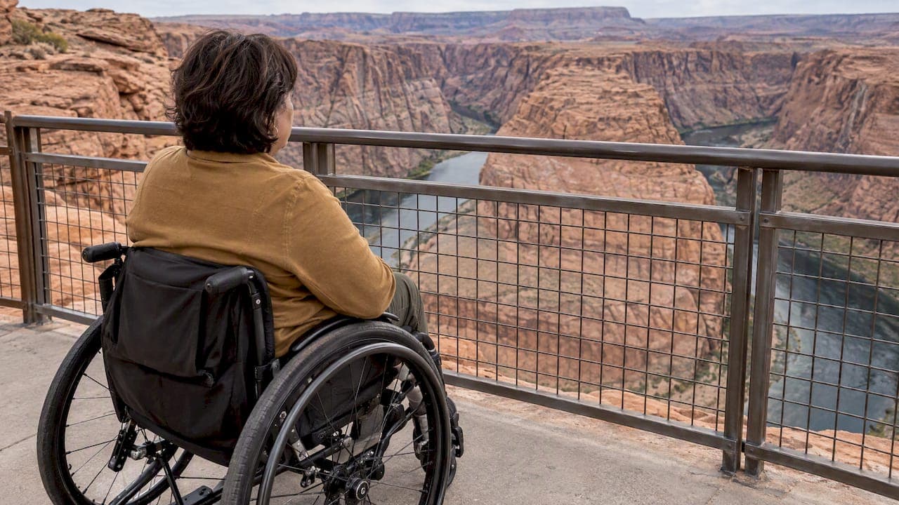
Yes, Horseshoe Bend is wheelchair accessible, with limits. The National Park Service describes a trail from the parking lot to the overlook that meets Architectural Barriers Act (ABA) standards. It ends at a small accessible viewing area with a safety railing. What it does not offer is a barrier-free rim. Most of the canyon edge is unfenced, rocky and about 1,000 feet above the Colorado River.
Below we cover what the accessible route is, what to expect on the ground, how parking and passes work, and how to plan around heat and shade. We also cover when a private, guided visit makes the day easier.
TL;DR
- The hardened trail to the overlook is about 1.5 miles round trip and meets ABA standards. It is open to wheelchairs, strollers and leashed dogs.
- The railed viewing platform is the accessible endpoint. The wider rim has no railings and is not an accessible or safe route.
- You cannot drive to the overlook. Parking is on City of Page land, so an America the Beautiful pass does not cover it.
- There are two shade structures on the trail, none at the overlook, and no toilets along the way. Use the parking-lot facilities first and carry water.
- Go early or late in the day. Heat and exposure are the biggest barriers for most visitors.
Table of Contents
- What "accessible" means at Horseshoe Bend
- Getting there: parking, passes and the drive
- Heat, shade and timing
- A quick accessibility checklist
- Our perspective
- Seeing Horseshoe Bend on a private tour
- Before you go: a planning list
- FAQ
- Sources
What "accessible" means at Horseshoe Bend
The trail to the rim was rebuilt in recent years. The NPS accessibility page for Glen Canyon National Recreation Area lists the recently completed ADA/ABA trail at Horseshoe Bend. It also says the park's rugged landscape can present difficult challenges for visitors with special needs, and that improvements are made each year.
Read "accessible" here as describing two things only:
- The constructed route from the lot to the overlook.
- The designated viewing area at its end.
The NPS describes the hike as 1.5 miles (2.4 km) round trip over a hardened path. That is not a promise that every surface, edge or photo spot along the rim can be reached. Stay on the path and behind the railing.
The route in practice
The path is packed, fairly flat and wide enough for a wheelchair, a stroller or a companion walking beside you. The Page tourism office puts the walk at about 20 minutes each way for a typical walker, with 137 feet of elevation gain. Allow more if you are pushing a chair, resting often or traveling with someone who tires easily.
Some practical points:
- Chairs: A manual chair on a hardened path is workable for many users, though the gentle climb on the way back can tire a pusher. Power chairs and chairs with larger or all-terrain tires will feel more secure. Sand drifts and loose gravel can build up at the edges of any desert path. Check your own chair's clearance and your helper's stamina honestly.
- Strollers: The NPS and the Page visitor office both say strollers are welcome on the trail.
- Leashed dogs: Pets are allowed on a leash. Keep them well away from the rim.
- Rest stops: There are two shade structures along the route. That is enough for a break, but not enough to make the walk shaded.
The viewing platform and the open rim
The NPS describes the platform as the fenced accessible area, with railings at its edge. It is the place to take the classic view in safety. Beyond it, the rim stays exposed, and the NPS tells visitors to watch their footing and keep track of children.
The agency has documented a fatal fall on February 14, 2022 involving a visitor outside the safety railing. The Utah Geological Survey also notes a partly detached block of Navajo Sandstone near the overlook as a high hazard. We do not know of any reliable official count of how many people have fallen here over the years, and we would not trust a figure that claims one.
For wheelchair users, the takeaway is simple. Treat the railing as the boundary, and keep mobility devices, children and pets back from unrailed edges. Our own Horseshoe Bend safety guide goes through the rules and the drop in more detail.
Getting there: parking, passes and the drive
Horseshoe Bend is reachable by car, but only as far as the trailhead. The NPS lists the lot off US Highway 89 between mile markers 545 and 544, about 5 miles (8 km) south of the Carl Hayden Visitor Center. There is no drive-up overlook, so everyone covers the trail on foot or wheels. The tourism office notes that the large lot has accessible parking, plus space for vans, RVs and buses.

Why your federal pass does not work
This surprises many visitors. The overlook sits within Glen Canyon National Recreation Area, but the parking lot belongs to the City of Page. The city's charge is separate, and federal and Glen Canyon passes are not accepted for it. That includes the America the Beautiful pass, and it means you should budget for parking even if you hold an Access Pass.

The Page tourism office lists the entrance fee as starting at $10 per vehicle, with national park passes not accepted. Fees and payment methods can change, so confirm them before you go. For a longer walk through the lot, the gate and what to expect, see our Horseshoe Bend parking guide.
Hours and facilities
The NPS lists the trail and overlook as open from sunrise to sunset. There are no toilets along the trail, so use the parking-lot restrooms before you start. Planning around restrooms, hours and conditions matters on any outdoor trip with mobility needs. Even a remote wildlife destination like Turtle Island in Borneo rewards checking those basics ahead of time.
Heat, shade and timing
For most visitors with limited mobility, the distance is not the problem. The environment is. Day-hike guidance from the NPS for Glen Canyon stresses little shade, desert heat, limited amenities and, elsewhere in the recreation area, patchy cell service. The same guidance says an easy route still needs water, weather planning and a start time that avoids the hottest hours.
A workable plan:
- Pick your time. Early morning or the last hour before sunset is easier on the body than midday. Our photography timing tips explain why arriving 45 to 60 minutes early also helps with crowds and light.
- Carry more water than seems necessary. There is none on the trail.
- Cover up. Hat, sunscreen and sturdy shoes matter even on a hardened path.
- Check conditions. The NPS Leave No Trace page warns that strong winds, extreme heat, storms and flash floods can all affect plans in summer.
- Budget the time. Our Horseshoe Bend time guide suggests planning 45 to 90 minutes in total. Allow the longer end if anyone in your group moves slowly.
A quick accessibility checklist
| Question | Short answer |
|---|---|
| Is there an accessible trail? | Yes, a hardened ABA-compliant path of about 1.5 miles round trip |
| Is there an accessible viewing spot? | Yes, a small railed platform at the end |
| Can I drive to the overlook? | No, parking is at the trailhead |
| Does my national park pass cover parking? | No, the City of Page runs the lot |
| Is there shade? | Two shade structures on the trail, none at the overlook |
| Are there restrooms on the trail? | No, use the lot facilities first |
| Is the whole rim accessible? | No, most of it is unrailed and exposed |
Our perspective
We are a locally owned private tour operator in Northern Arizona, and Horseshoe Bend is one of the places our guests ask about most. When someone writes to ask whether a parent, a child in a stroller or a family member with limited mobility can manage it, our honest answer is usually yes for the platform and no for the wild rim. The viewpoint is the point. You do not need to stand at an unprotected edge to take in the bend.
The things that catch people out are rarely the trail itself. They are the midday sun, the separate parking charge, the lack of restrooms along the way and the long drive to get here. From Sedona, it is a full day, as we explain in our Sedona to Page day trip guide. When mobility is a concern, we would rather you think through energy and timing than rush.
If you travel with someone who needs extra time, tell us before you book. We run every tour privately, with door-to-door pickup and a flexible pace, so the day can be built around your group instead of a shared schedule. Our Arizona accessibility guide is the place to start, and we will talk through your specific needs before anything is confirmed.
— Chris
Seeing Horseshoe Bend on a private tour
A self-drive visit works well for many travelers. A guided one suits others, especially when the drive and the heat are the real challenge. Our Antelope Canyon & Horseshoe Bend tour from Sedona is a private, Navajo-guided day with door-to-door pickup, and it is listed from 419 USD per person. Tours are private, never shared buses, and itineraries are flexible. That matters if someone needs more time at the platform, more breaks or a different pace.
We do not publish a mobility-specific version of this tour, so describe your group's needs when you contact us, and we will tell you plainly what is and is not realistic. You can compare all departures on our tours page, or read more about the Horseshoe Bend experience and the nearby Antelope Canyon.
If you are combining the viewpoint with other stops, our one-day Horseshoe Bend and Antelope Canyon plan shows how the day fits together. Visitors planning a wider Arizona trip can also look at our Grand Canyon travel planner.
Before you go: a planning list
- Confirm current parking fees and payment methods with the City of Page or the visitor office.
- Check the forecast, including wind and heat.
- Decide in advance who stays on the platform, and who holds the stroller or chair when someone wants a closer look.
- Pack water, a hat, sunscreen and any medication you may need during a 45 to 90 minute outing.
- Use the restroom at the lot before you start.
- Accept that the best photo may come from the railed platform, not the edge.
FAQ
Is Horseshoe Bend ADA accessible?
The NPS describes the trail to the overlook as accessible under ADA and ABA standards. The accessible viewing area is a small platform at the end. The rest of the rim is rocky and unrailed, so it is not accessible and not safe for mobility devices.
Is Horseshoe Bend wheelchair accessible?
Yes, to the designated platform. The route is a hardened path of about 1.5 miles round trip, and the NPS calls it wheelchair friendly. Think about your chair's tires, the gentle climb on the return and the heat before you go. Strong pushers or a power chair make the walk easier.
Can I use my America the Beautiful pass at Horseshoe Bend?
No. The parking lot is on City of Page land, and the NPS says federal and Glen Canyon passes are not accepted for the city's parking charge. Plan to pay the separate fee even if you hold an annual or Access Pass.
Is Horseshoe Bend accessible by car?
Yes, as far as the parking lot off US Highway 89. There is no drive-up overlook, so you must go from the lot along the 1.5-mile round-trip trail. The lot has accessible spaces and room for larger vehicles.
How many people have fallen at Horseshoe Bend?
There is no reliable official total. The NPS documented a fatal fall on February 14, 2022, involving a visitor outside the safety railing. Staying on the path and behind the railing is the way to avoid the risk.
Sources
- Accessibility, Glen Canyon National Recreation Area (NPS)
- Take a stroll to Horseshoe Bend Overlook (NPS)
- Horseshoe Bend, Glen Canyon National Recreation Area (NPS)
- Fees & Passes, Glen Canyon National Recreation Area (NPS)
- Day Hikes, Glen Canyon National Recreation Area (NPS)
- Leave No Trace at Glen Canyon (NPS)
- Horseshoe Bend Overlook Fatality, Feb 14, 2022 (NPS)
- Geologic Hazard Mapping in Glen Canyon National Recreation Area (Utah Geological Survey)
- Visiting Horseshoe Bend, AZ (Visit Page Arizona)